Introducing BuildingPoint Spatial Scanning Services
 Today, BuildingPoint is thrilled to announce a revolutionary new way of acquiring and consuming highly accurate as-built data. Leveraging decades of combined experience within the laser scanning and as-built on-site data acquisition fields, BuildingPoint has created an entirely unique method of collecting and presenting high-accuracy 3D point clouds, 2D floorplans, and 3D models. As a standalone offering, BuildingPoint Spatial Scanning Services provides contractors, designers, and project stakeholders with easily consumable data. And because every project is different, BuildingPoint Spatial Scanning Services is designed to be modular and customizable, easily conforming to the needs and requirements of each individual project.
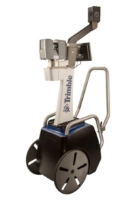
Spatial Scanning Services is the melding of several different technologies into one streamlined service. Combining the best attributes of traditional static scanning, cart-based mobile mapping, panoramic imagery, and industry leading post-processing technologies, BuildingPoint can easily turn large data sets and point clouds into fully registered deliverables in days, rather than weeks compared to traditional methods. Additionally, this blended services places a huge premium on both speed and accuracy, with on-site scans and data acquisition being completed 4-7x quicker than traditional scanning methods.
To learn more about BuildingPoint Spatial Scanning Services, or to schedule a discovery discussion on your next project, contact your BuildingPoint representative today. Or, if you'd like to learn more, check out our numerous videos and related content by heading over to buildingpointflorida.com/scanning
You must be logged in to post a comment.